
A traffic-navigation app called Waze is taking over the roadways and drawing controversy for encouraging cut-through traffic in neighborhoods locally and nationwide.
A recent experiment with Waze found the app indeed directs drivers through quiet neighborhood streets in Buckhead, Dunwoody and Sandy Springs. But, ironically, Waze would not send drivers into a Brookhaven neighborhood that has been a hot spot of protests about app-driven traffic.
With the motto “Outsmarting traffic, together,” Waze uses a combination of GPS tracking and local roadway information crowdsourced from its own users. It both directs drivers to their destinations by the fastest route and allows them to report where heavy traffic is, where road work is happening, and even where police have set up roadblocks.
Waze advertises 50 million users worldwide. It has gained popularity from drivers, and disdain from some neighborhoods, because its disembodied voice often directs users to back roads, side streets and through residential neighborhoods which were once only known to locals.
Georgia Tech traffic engineering professor Michael Hunter says such apps are making traffic harder to predict. Elected officials are concerned, too. Sandy Springs Mayor Rusty Paul has voiced concerns that drivers heading to the forthcoming Braves stadium in Cobb County will “start Waze-ing their way” through city neighborhoods. In Brookhaven, City Councilmember Bates Mattison was quoted in the Washington Post in June about Waze complaints there. But Waze also partners with governments on traffic-mapping, including with the Georgia Department of Transportation and the city of Atlanta.
Here is where Waze directed drivers during recent experiments in Reporter Newspapers communities:
Buckhead to Sandy Springs
Destination: From 103 West Paces Ferry Road to Reporter Newspapers at 6065 Roswell Road.
Waze’s route: Waze directed drivers through Tuxedo Park neighborhoods via Habersham Road, including some streets with traffic-calming speed humps, then to Lake Forrest Drive. Traffic was light.
Brookhaven and Sandy Springs to Buford Highway

Destinations: From Sandy Springs’ High Point Road to Buford Farmer’s Market; and from Peachtree Road Kroger and Brookhaven City Hall to Plaza Fiesta.
Waze’s route: On all three rush-hour trips, Waze directed drivers through central Brookhaven via Dresden Drive.
Last month, Brookhaven City Council approved extensive traffic-calming measures—including dozens more speed humps and partially closed roads—in the Brookhaven Heights neighborhood. The intent of the plan is to thwart Waze-users and other motorists from cutting through the residential neighborhood off North Druid Hills Road.
But in all three trips of the recent experiment, Waze never directed drivers through Brookhaven Heights, instead using Dresden Drive about a block away. The traffic-calming devices are not yet installed but expected to be by the end of the year.
A Waze spokesperson said the city of Brookhaven has not contacted the company about traffic in the neighborhood. Julie Mossler, Head of Brand for Waze, said in an email that Waze maps reflect current reality of local roads and that citizens have the right to use any public roads that are open to all.
“Waze will not make edits that do not reflect the true condition of a street (closing a road that is indeed open) — too many emergency vehicles use our service and need the most accurate, fastest route, and we believe citizens have a right to use any public roads that are open to all,” Mossler said.
Mossler noted Waze currently work with 80 municipalities, including the Georgia DOT, City of Atlanta and three other Georgia organizations, through the Waze Connected Citizens Program, a free, two-way data exchange “empowering municipalities to harness real-time driver insights to improve congestion and make better informed planning decisions.”
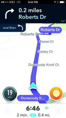
Sandy Springs to Dunwoody
Destination: From the Reporter Newspapers office on Roswell Road to the Dunwoody Nature Center on Roberts Drive.
Waze’s route: The app sent drivers to Dalrymple Road in Sandy Springs onto Chamblee-Dunwoody Road in Dunwoody. It then directed drivers to cut through the quiet residential street Dunwoody Knoll Drive.
Not Irony: “But, ironically, Waze would not send drivers into a Brookhaven neighborhood that has been a hot spot of protests about app-driven traffic.”
Eric,
You are absolutely correct along with many drivers being aggressive, irritated and distracted while texting, talking on their cell phone, drinking coffee, or possibly putting on make up while zipping through the neighborhood.
With respect to the “advantages” described above, that is from the perspective of a non-resident. For those of us being Wazed, our residential streets have become dangerous places during AM and PM rush hours.
I do agree however with the point that it’s up to the DOT and municipalities to invest in road/ highway infrastructure in order to handle the volume of traffic in our city. It doesn’t seem right that residential neighborhoods have to bear the burden of what is not being done by others.
These are “Public” roads not private streets. IF you want a private street then follow the law for a HOA and put up a gate. Otherwise all the complaints are just sour grapes.