
Sandy Springs wants to build trails to the Chattahoochee River and is planning to create a master plan to guide their development. The study is beginning as regional connectivity project on a larger section of the river begins to take shape.
Sandy Springs’ effort was spurred by a recommendation from a task force that studied redevelopment of the city’s north end last year. Making better connections to the river was seen by the task force as a way to make the area of the city more attractive for residents and developers.
The other study is being done through a partnership between the city of Atlanta, Cobb County, the Trust for Public Land and the Atlanta Regional Commission. It will also incorporate Sandy Springs’ plans.
The regional project, dubbed the Chattahoochee RiverLands Greenway Study, is planned to include new parks, hiking trails, boat ramps, bicycle paths and other amenities along a 100-mile stretch from the Chattahoochee Bend State Park in Coweta County up to Lake Lanier, traversing the riverfront through northwest Buckhead and around Sandy Springs along the way.
Sandy Springs is looking for a firm to develop a master plan that would guide the development of trails and connections. A big challenge to building trails, or any development, around the river, are the federal restrictions on how the land can be used.
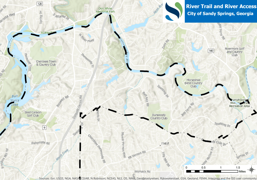
Much of Sandy Springs’ border is the river and large sections of it are difficult to access, other than the Chattahoochee River National Recreation Areas operated by the National Park Service.
The North End Revitalization Task Force recommended in its report last year that more connections be created to spur redevelopment in the area. The city is also seeking a study on redeveloping four large shopping centers on the north end, another part of the task force’s recommendations.
The city is seeking a firm to create the master plan and released a request for proposals June 5.
Three open house meetings would be held for the public to provide input on the plan, the document said. Meetings with such groups as the Atlanta Regional Commission, city staff, Georgia Department of Natural Resources and others would also be held.
The contractor would be required to a review of the existing land uses, zoning and utilities. It would also need to produce a list of all the agencies with legal jurisdiction that would be involved.
Byron Rushing, the ARC’s bicycling and walking program manager, said the seeing local governments take up their projects is one of the “really exciting parts” of working on the RiverLands study. Any Sandy Springs work will also be used with the RiverLands study, he said.
“It’s cool to see the local momentum,” he said. “We’ll pull that in and use as much as we can.”
The goal of RiverLands study is to create new access to the river and allow the public to use much more of it, Rushing said.
“The Chattahoochee River is one of our region’s natural treasures, but in many areas access remains limited. This study presents an enormous opportunity to change that,” he said.
Walt Ray, the Trust for Public Land’s Chattahoochee River Program director, said that Sandy Springs was an early participant in the greenway study.
The study has been in development for over year, and during that time the team has met with hundreds of stakeholders, Ray said.
“Now, we feel like it’s time to go public,” he said. “This is a sort of once-in-a-generation opportunity.”
The 18-month long study began in October 2018 and is being led by SCAPE, a New York-based landscape architecture and urban design studio.
“The Chattahoochee RiverLands Greenway Study presents the largest, most comprehensive effort to reimagine the role the Chattahoochee River plays in our region,” Ray said.
The first two public meetings for the study were set for outside of Sandy Springs, but residents are encouraged to participate, Ray said. As the study moves forward, more meetings and events will be held, including interactive “River Rambles,” or festivals, along the river, Ray said.
Over the summer, the RiverLands team will being crafting the “visionary plan” to bring back to the public later, Ray said.
The federal regulations remain a challenge for the Greenway study as well. Rushing said the part of the study is understanding all the restrictions that protect the river and guide development around it.
“To some degree, environmental regulations do dictate what we can do,” Rushing said.
Anything the RiverLands study calls for adding would also have to go around development that exists, he said.